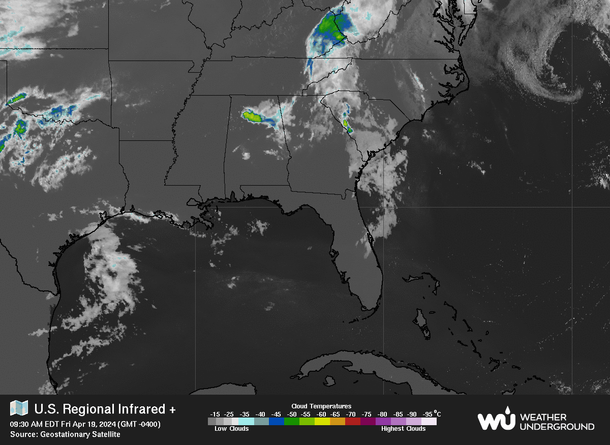
Top Warning Information Unavailable, error fetching or reading data from the NOAA advisories server.
Regional Radar Regional Infrared Satellite
CURRENT CONDITIONS at US41 and Midway in Port Charlotte
spacer
Updated: @ 29-Sep-2021 5:06pm - next update at 5:08pm  
Summary / Temperature Wind . Outlook
Clear Clear
Currently: 87.1°F, Max: 87.1°F, Min: 68.0°F 87.1°F
Warmer 1.0°F than last hour.

---

Feels like: 87.8°F

24-hr difference
0°F 
  Today Yesterday
High: 87.1°F
2:01pm
89.1°F
4:01pm
Low: 68.0°F
7:01am
69.1°F
4:01am
Cloud Base
Cloud Formation
Approximate Height:
5621 ft

Wind from E
E  6.0 mph
Gust: 6.0 mph


2 Bft - Light Breeze

Saturday

Saturday: Scattered showers and thunderstorms before 2pm, then showers likely and possibly a thunderstorm between 2pm and 5pm, then scattered showers and thunderstorms after 5pm.  Mostly sunny, with a high near 93. Heat index values as high as 102. Calm wind becoming northwest around 5 mph in the afternoon.  Chance of precipitation is 60%. New rainfall amounts between a half and three quarters of an inch possible.
High: 93 °F
Humidity & Barometer Almanac Moon
Humidity: 44 % Decreased 4.0% since last hour.
Dew Point: 62.5°F Decreased 1.5°F since last hour.
Barometer: 29.940 inHg Falling 0.01  inHg/hr
Baro Trend: Steady
Moonrise: 12:33am
Moonset: 2:52pm
Sunrise: 7:20am
Sunset: 7:16pm
Waning Crescent
Waning Crescent, Moon at 22 days in cycle
42%
Illuminated
Max UV Today UV Forecast Tomorrow
   None
   None

Port Charlotte Florida - Charlotte County Weather - 5 Day Forecast
Click for Detailed Forecast and Information
Overnight

Overnight: Partly cloudy, with a low around 75. Calm wind.
Low: 75 °F
Saturday

Saturday: Scattered showers and thunderstorms before 2pm, then showers likely and possibly a thunderstorm between 2pm and 5pm, then scattered showers and thunderstorms after 5pm.  Mostly sunny, with a high near 93. Heat index values as high as 102. Calm wind becoming northwest around 5 mph in the afternoon.  Chance of precipitation is 60%. New rainfall amounts between a half and three quarters of an inch possible.
High: 93 °F
Saturday
Night
Saturday Night: Scattered showers and thunderstorms, mainly before 8pm.  Partly cloudy, with a low around 76. West wind around 5 mph becoming calm  in the evening.  Chance of precipitation is 30%.
Low: 76 °F
Sunday

Sunday: Scattered showers and thunderstorms, then showers likely and possibly a thunderstorm after 2pm.  Mostly sunny, with a high near 92. Heat index values as high as 102. Calm wind becoming west around 6 mph in the afternoon.  Chance of precipitation is 60%.
High: 92 °F
Sunday
Night
Sunday Night: Showers likely and possibly a thunderstorm before 8pm, then scattered showers and thunderstorms, mainly between 8pm and 2am.  Mostly cloudy, with a low around 76. West northwest wind around 6 mph becoming calm  in the evening.  Chance of precipitation is 60%.
Low: 76 °F
Monday

Monday: Isolated showers and thunderstorms, then showers and possibly a thunderstorm after 8am.  High near 90. Calm wind becoming west northwest 5 to 7 mph in the morning.  Chance of precipitation is 80%.
High: 90 °F
Monday
Night
Monday Night: Showers and possibly a thunderstorm before 8pm, then scattered showers and thunderstorms between 8pm and 2am.  Low around 74. Northwest wind around 6 mph becoming calm  in the evening.  Chance of precipitation is 80%.
Low: 74 °F
Tuesday

Tuesday: Scattered showers and thunderstorms between 8am and 2pm, then showers and possibly a thunderstorm after 2pm.  High near 89. Calm wind becoming south southwest around 6 mph in the afternoon.  Chance of precipitation is 90%.
High: 89 °F
Tuesday
Night
Tuesday Night: Showers and possibly a thunderstorm before 8pm, then scattered showers and thunderstorms, mainly between 8pm and 2am.  Low around 75. East southeast wind 3 to 5 mph.  Chance of precipitation is 80%.
Low: 75 °F
Partly Cloudy

Scattered
T-storms then
Showers
Likely
Scattered
Showers then
Partly Cloudy
Scattered
T-storms then
Showers
Likely
Showers
Likely then
Scattered
T-storms
Showers

Showers then
Scattered
T-storms
Scattered
T-storms then
Showers
Showers then
Scattered
T-storms
Forecast for Overnight
Partly cloudy, with a low around 75. Calm wind.
Extended Forecast Information

Charlotte County Weather
Port Charlotte Weather - SouthWest Florida Weather - Gulf Coast Weather - Punta Gorda Weather
Advertise with Charlotte County Weather! Click Here!
Local Area - Radar, IR, Satellite, Air Quality Maps, Fronts, Jet Stream and More!
Lee County Radar
Lee County Weather, Lee County Radar, Conditions, Forecasts, Fire Weather Analysis and Tides for Port Charlotte, Punta Gorda and the surrounding area. Live weather and Traffic Cams. 33952 33948 33983 33950 33982

Charlotte County Radar
Charlotte County Weather, Radar, Conditions, Forecasts, Fire Weather Analysis and Tides for Port Charlotte, Punta Gorda and the surrounding area. Live weather and Traffic Cams. 33952 33948 33983 33950 33982

Collier County Radar
Collier County Weather, Collier County Radar, Conditions, Forecasts, Fire Weather Analysis and Tides for Port Charlotte, Punta Gorda and the surrounding area. Live weather and Traffic Cams. 33952 33948 33983 33950 33982

Sarasota County Radar
Sarasota County Weather, Sarasota County Radar, Conditions, Forecasts, Fire Weather Analysis and Tides for Port Charlotte, Punta Gorda and the surrounding area. Live weather and Traffic Cams. 33952 33948 33983 33950 33982

Desoto County Radar
Desoto County Weather, Desoto County Radar, Arcadia Weather, Arcadia Radar, Arcadia Conditions, Forecasts, Fire Weather Analysis and Tides for Port Charlotte, Punta Gorda and the surrounding area. Live weather and Traffic Cams. 33952 33948 33983 33950 33982 34266

Glades County Radar
Glades County Weather, Glades County Radar, Conditions, Forecasts, Fire Weather Analysis and Tides for Port Charlotte, Punta Gorda and the surrounding area. Live weather and Traffic Cams. 33952 33948 33983 33950 33982

Orlando Area Radar
Orlando Radar, Disney World Radar, Universal Studios Radar, Sea World Radar, MGM Studios Radar, Epcot Radar

Key West Radar
Key West Radar, Florida Keys Radar, Southern Florida Radar

Miami Dade Radar
Miami Radar, Hollywood Radar, South Beach Radar, Dade County Radar, Fort Lauderdale Radar, South Florida Radar, Homestead Radar


Port Charlotte, Punta Gorda, Englewood, North Port, Cape Coral, Fort Myers, Bonita Springs, Sanibel,
Boca Grande, Gasparilla, Lehigh Acres, Captiva, Pine Island, Bokeelia, St. James City, Alva, Arcadia,
Labelle, Clewiston, Venice, Desoto County, Charlotte County, Lee County, Sarasota County,
Collier County, Hendry County, Monroe County, Naples, Estero